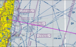
In Sugar Alpha, there’s a lot of pilot-speak. When I originally drafted the book, I wanted non-skydivers and non-aviators to also enjoy the story. However, without destroying the plot in defining terms, I had created a glossary of terms. The glossary didn’t make it in the final cut. So this post is for my non-aviators to illustrate some of the terms used in the book.
ADIZ is the area around the U.S. ’ eastern, southern, and western borders where aircraft must identify themselves and their position to Air Traffic Control prior to entering.
LORAN (LOng RAnge Navigation) is a terrestrial radio navigation system which enables ships and aircraft to determine their position and speed from low frequency radio signals transmitted by fixed land based radio beacons, using a receiver unit. This is what was used prior to the GPS (Global Position System).
GNC Aviation Map [Global Navigational Chart] – an aeronautical chart used for high altitude, high speed, extended long range flights that include towns, primary roads/railroads, and spot elevations to help navigate
Official Airline Guide [OAG] – a comprehensive commercial airline guide comprising airport codes, aircraft seating, and flight schedules
VOR [VHF Omni-Directional Radio Range] – a ground based radio navigation aid that helps pilots determine their location
Although I grew up in aviation and understood most of these terms, I was only just finishing my private Pilot’s License while I was finishing Sugar Alpha. It was such a fascinating perspective on my dad’s escapades becoming a pilot!


